

Hurricane Ian Leaves a Path of Destruction in the Southeast
A Debrief of One of the Strongest Storms in US History
Due to the nature of its location in the American Southeast, Charleston is no stranger to the destruction of hurricanes. However, we have gotten lucky the past few years, with our most recent hurricane landfall being Hurricane Dorian in 2019. This year, as Hurricane Ian rolled in from the gulf, many were left in the dark about what would happen to our beloved city. Here is a day-to-day summary of Hurricane Ian, from President Biden declaring an emergency on September 24 to the final assessment of the aftermath in Charleston and Florida.
September 24, 2022
On September 24, President Biden declared that there was an emergency situation in Florida (not to be confused with a state of emergency). He then ordered federal aid to the state ahead of the incoming storm. The White House released a statement saying that Biden “[authorized] the Department of Homeland Security, Federal Emergency Management Agency (FEMA), to coordinate all disaster relief efforts” for “the counties of Brevard, Broward, Charlotte, Collier, Desoto, Glades, Hardee, Hendry, Highlands, Hillsborough, Indian River, Lee, Manatee, Martin, Miami-Dade, Monroe, Okeechobee, Osceola, Palm Beach, Pasco, Pinellas, Polk, Sarasota, and St. Lucie and the Miccosukee Tribe of Indians of Florida and the Seminole Tribe of Florida” (whitehouse.gov). The Floridian government had begun to make preparations, such as issuing school closures in counties along the Gulf Coast, as Ian was categorized as a tropical storm.
September 26, 2022
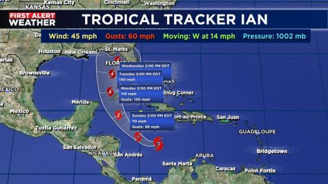
Monday Morning: Ian had upgraded to a Category 1 hurricane. The National Weather Service was predicting it to be a Category 4 landfall over Florida. At this point, the maximum sustained winds were 130 miles per hour. Because this storm was approaching the US from the Gulf of Mexico, it presented a unique set of challenges. Hurricanes coming from the gulf are often stronger because of the warm temperatures of the water. Also, because the gulf is almost entirely surrounded by land, hurricanes are contained in a small, warm space, letting them bounce around and become very strong, rather than dissipate as many of the Atlantic hurricanes do. As the hurricane began to near Cuba, Florida’s Governor DeSantis declared a state of emergency. Experts believed that Ian would hit western Cuba as a Category 3 storm on September 27 at 2:00 AM EDT.
Monday Evening: Ian strengthened to a Category 2 storm and the outer bands of rain began to hit Florida.
September 27, 2022
Tuesday Morning: At around 4 AM EDT, Ian made landfall in western Cuba as a Cat 3. This caused the country to go under an almost total blackout, which took days to get power back. As Ian left Cuba, the expected path changed, with Ian predicted to hit lower on the Florida peninsula than what was thought. However, it was still predicted to be a Cat 4 landfall. It was also expected to hit Charleston as a tropical depression.
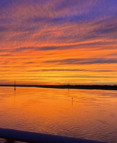
Tuesday Evening: DeSantis issued evacuation orders for these counties: Charlotte, Citrus, Collier, Hernando, Hillsborough, Lee, Levy, Manatee, Pasco, Pinellas, Putnam, and Sarasota. Charleston was put under a tropical storm watch that evening. As the storm’s outer bands made it up the Atlantic Coast, many areas were left with stunning sunsets, which seemed to be the “calm before the storm.”
September 28, 2022
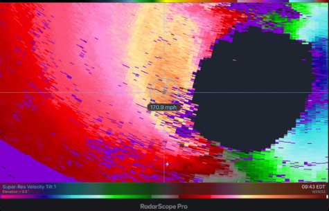
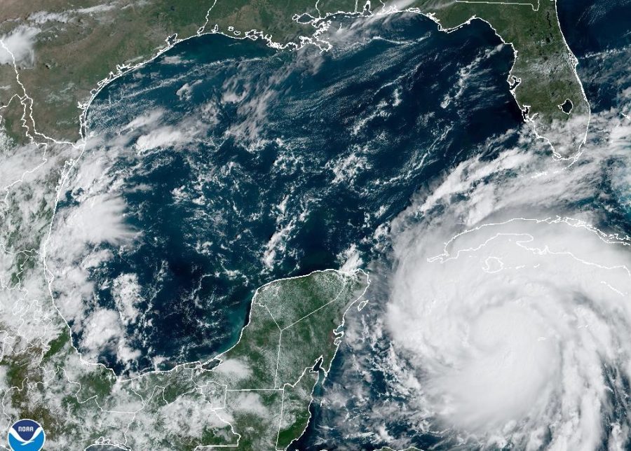
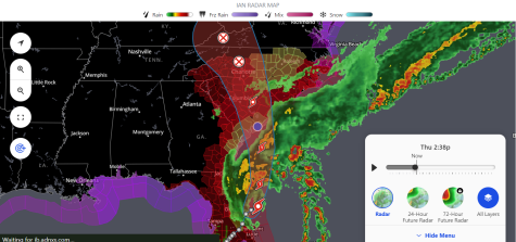
Wednesday Morning: Cuba was finally able to work to get power back up after the country was left without power. As of 9 AM EDT, the eye of the hurricane was just off of the coast of southwest Florida, waiting to make its Category 4 landfall. It was reported that the sustained wind speeds were just off of the requirement for a Cat 5, which is very rare for the US. Twitter user Justin Fleenor (@JustinFleenor), posted satellite images indicating the extreme wind velocities along the eyewall. Not only was this concerning, but the eye itself was also massive, with the ability to fit another recent hurricane within the eye. This meant widespread devastation across Florida. Once again, the probability cone had shifted and was predicting that Ian would make a second landfall in Savannah, GA as a tropical storm.
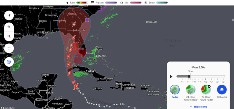
Wednesday Afternoon and Evening: Tampa Bay and other bodies of water that lead to the Gulf had begun to empty, which meant that all of that water and more would return as huge storm surges. At 3:05 PM EDT, Ian was about to make landfall but seemed to be parked just off of the coast, with 155 mph sustained winds. At 4 PM EDT, Ian made landfall and began to quickly move over Florida. A hurricane watch was issued for Savannah, Charleston, and coastal Colleton and Berkley Counties. CCSD issued school closures for Thursday and Friday.
September 29, 2022
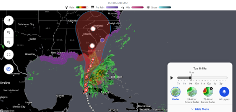
At around 2 AM, Ian had downgraded to a Cat 1 hurricane over Orlando and was predicted to now head straight for Charleston. As it reached the cooler waters of the Atlantic, it downgraded to a tropical storm but was expected to quickly pick back up as a Cat 1 at 8 AM on Friday. Luckily it was predicted to quickly move down to a tropical storm as it moved over Columbia. The bands of the storm continued to make their way up to the Northeast, stretching to practically the entire length of the US Atlantic Coast.
September 30, 2022
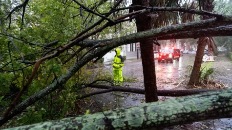
After many changes in the predicted location of Ian’s second landfall, it finally hit Georgetown, SC on Friday. Leaving most of Charleston waterlogged and without power. According to the National Hurricane Center, the storm had winds of 85 mph as it reached South Carolina. Luckily, Charleston did not receive any extreme damages, unlike most of Florida, which was left absolutely decimated in the wake of Ian.
Aftermath
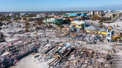
As the storm cleared, the nation was able to see just how destroyed Florida was. In Fort Myers, homes seemed to have completely disappeared, most likely having been sucked out to sea after the storm surge. It seemed as if the city had been completely flattened by the storm. Many people were missing from the area, but efforts are being made to bring the city back to its original condition. In other areas of Florida, many are now completely homeless and have lost thousands of dollars in property, including cars and boats. Some barrier islands seemed to have disappeared, and many that had low-lying access roads to them had lost the ability to travel back to the mainland. FEMA, the National Guard, and the Coast Guard have been working diligently on search-and-rescue operations to get stranded citizens to safe areas and to wait for the flooding to recede.